


Warriors Path State Park – Outside of Colonial Heights – Multi-use – Map – This park is off of I-81 at exit 63. See map for directions to the park.
There are trails at the State Park proper and then where we went was a group of about 10 miles of mountain bike trails. We opted for a 6 mile loop consisting on Darwin’s Revenge, Boneyard, Rock City, and then headed back on the Lake Valley Road (access road). This would be a really nice trail system for both running and biking with rolling to mild hilly terrain with rocks, rock drop offs, and views of the river.
Tanasi – Ocoee Whitewater Center outside of Chatanooga/Cleveland. Multi-use – I took the info off the IMBA epic rides link.
This is a network of 3 single track loops joined together by jeep roads. Fun ride. We saw a black bear from about 15 feet away (we waved, took a picture, and were on our way). Ran into a couple at the parking lot that ran into two bears eating blackberries. One was laying on it’s back sprawled out pulling the berries down toward it’s mouth and the other was laying down on it’s stomach.
Racoon Mountain – Chatanooga – Multi-use – MAP – This is a SORBA built gem.
There has been a ton of work done around this reservoir. Lots of great rolling single track. 1000’s of hours have been put into this area. SORBA plans to add another 7.5 miles of trail up here. Highly recommended. This place has been mentioned quite a few times on the IMBA site and in their quarterly publications.
Prentice Cooper State Forest and Wildlife Management Area Chattanooga – Foot Travel Only
This area hosts a 9.75 mile loop of the Stump Jump 50k and a 22 mile figure eight loop as part of the 3 day stage race that is scheduled in June. This is a scenic primitive trail. Not a lot of foot traffic out here. We parked at the first Cumberland Trail Parking Lot off of Tower Road.
Sewanee Domain – Sewanee – MAP – Multi-use
We came to the University of the South to bike the 20 mile perimeter trail. You can park at the entrance gate off of HWY 41 or a number of places within the school property. The perimeter trail meandered around the property perimeter, on the edge of rock cliffs, the occasional overlook, sometimes smooth trail, and sometimes rocky trail. I really enjoyed the look and feel of the trail but there were a lot of places where we got off our bikes to get over or through an obstacle (usually rock(s)). This place was really scenic and had a feel of Montreat outside of Asheville, NC. I’d love to come back when I’m better prepared for the terrain. There are a lot of side trails and service roads. You could be here all day. Afterwards we hit the Blue Chair Coffee House for a coffee and muffin/scone.
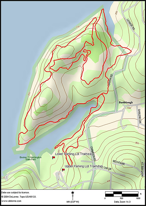
Booker T Washington State Park – Chattanooga – MAP – Multi-use
This was a 5.4 mile loop. It was a well maintained, well worn trail that turn and twisted through the park and around the lake. They have a number of trail running and mtn biking races here throughout the year. We ran in a counter clockwise direction (The mountain bike races travel clockwise). It was a nice loop and a nice choice for an easier low mileage day.
Smokemont Loop Trail to Chasteen Creek Cascades (Hiking Only) – Great Smokey Mtn. National Park – Hiking-Running – 6.5 mile loop with 1660ft of elevation gain/loss.
This was on the way from Asheville to Gatlinburg off of 441N at the Smokemont Campground. We parked at the exit of the campgound in front of the gate where there is an old bridge over the creek. The first 3 miles, of the 4.9 mile Smokemont Loop Trail starts with a pretty good climb. From here the trail drops just as fast as it rose. After you cross the log bridge the trail splits where you will want to head to the right on the Bradley Fork Trail. You will be on this for .5 miles to the intersection with the Chasteen Creek Trail. From here you will want to head to the left for .7 miles on the trail to view the Chasteen Creek Cascades. This trail (a rocky old road) gently climbs. At the .7 mile mark there will be a trail heading off to the left. There is a hitching area for horses and at the back there is a small trail that continues to the cascades. Once you’ve had your fill of cascading water you will want to head back down to the Smokemont Campground (1.9 miles from the cascades; .7 miles on the Chasteen Creek Trail and 1.2 miles on the Bradley Fork Trail).
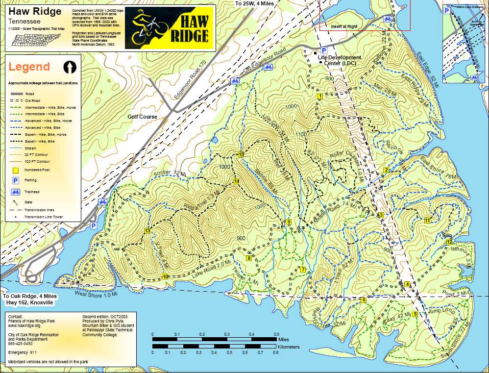
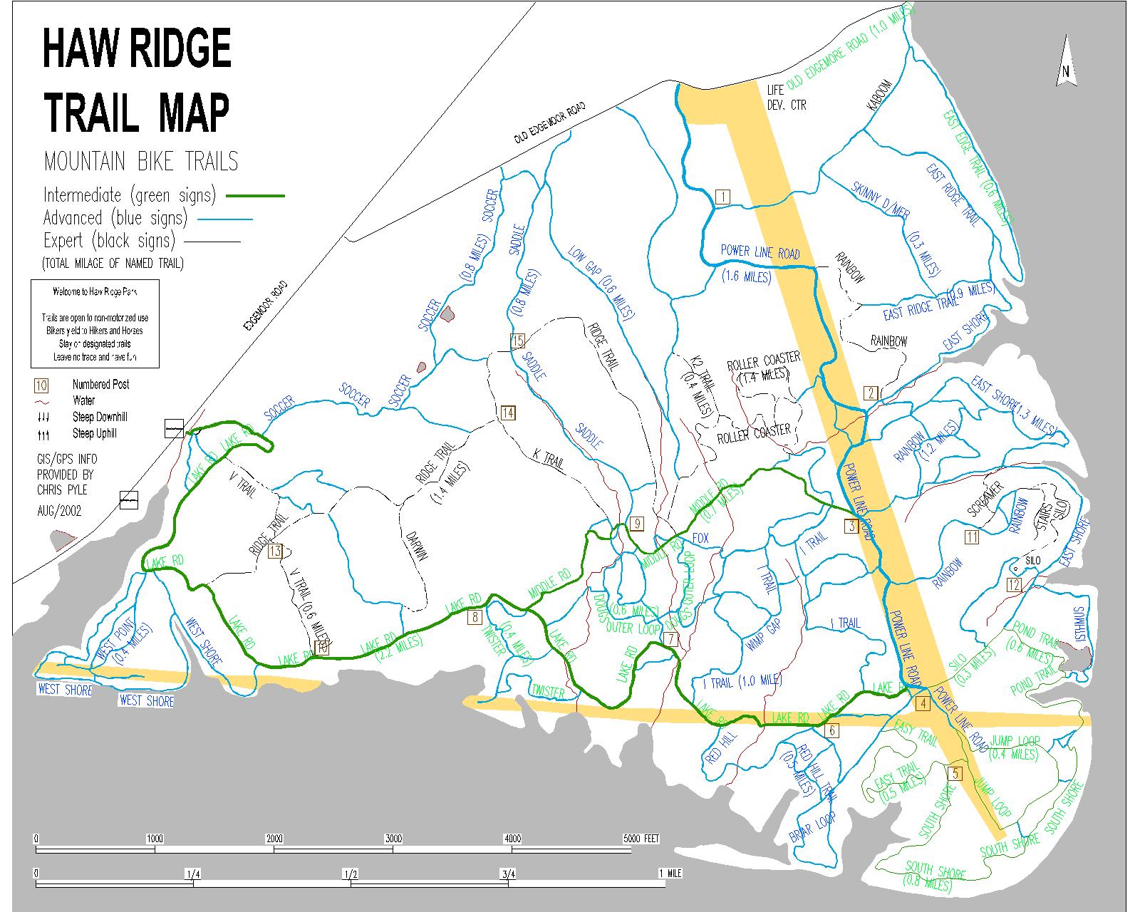
Haw Ridge – Oak Ridge north of Knoxville – MAP 1 – MAP 2 – Multi-use
It started to pour rain on us as we left Chattanooga but we continued on to Haw Ridge to get in a run (it is posted to not ride on the trails if wet). We parked at the pull off/boat launch just before the entrance to Haw Ridge Park off of Route 170. This place was really rocky and rooty. Most of the trails were short and you could piece together a lot of different loops here. We did a 5.5 mile run. We choose some of the trails around the shore line and then headed up and over the ridge to end the run.